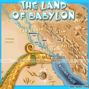
 Land of Ancient Babylon - Topo Color Map (72 DPI) 1-Year License
Full Catalog

Zephaniah Judah – Basic Map (72 DPI) 1-Year License
$20.00
Basic map of Zephaniah Judah.
695 x 1061px, 72dpi
It can be used for projection, lamination or color print from postcard to poster size.
[One Year License]
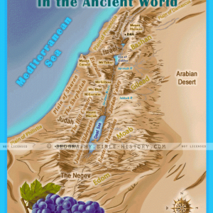
The map shows the territory of the kingdom of Judah at the time of the prophet Zephaniah, who lived in the 7th century BCE. The kingdom was located in the southern Levant, and it was bordered by the kingdoms of Israel and Ammon to the north, Moab to the east, and the Philistines to the west. The capital of Judah was Jerusalem.
The map also shows the major cities and towns of Judah, including Jerusalem, Hebron, Bethlehem, Jericho, and Beersheba. It also shows the major rivers and bodies of water in the region, including the Jordan River, the Dead Sea, and the Mediterranean Sea.
The map is labeled with the names of the different geographical features, as well as the names of the ancient kingdoms and empires. It is a valuable resource for anyone who is interested in the history of the region during this time period.
Here are some additional details about the map:
- The map is oriented with north to the top.
- The scale of the map is not given, but it appears to be a relatively large-scale map.
- The map is drawn in a simple, but effective, style.
- The colors used on the map are muted, but they are still easy to see.
- The map is well-labeled, making it easy to identify the different geographical features and political entities.
This map is available as a high resolution digital download with detailed instructions. You must bring the file to an Office Depot or similar store for easy color print and lamination. For personal, church or classroom use only.